
< Return to insights hub
- August 12, 2026
LightWare LRF Performance Over Water: A Practical Test
Water may be the planet’s most precious resource but it’s also one of the most volatile.
This unpredictability can make distance sensing with laser rangefinders (LRFs) or UAV altitude sensing over water incredibly challenging.
The liquid surface introduces a combination of reflection, absorption, and scattering effects that can either make distance measurement unreliable or, in the most severe cases, completely unusable.
The big question is how these scenarios can be successfully negotiated.
To determine the answer, we evaluated a range of LightWare microLiDAR® distance sensors and LRFs over water to establish how they perform in real-world deployment situations.
Why Water Is Challenging for LRFs
Water can interfere with return signals for a variety of reasons.
Specular reflection may cause the laser to reflect away from the sensor, while water often absorbs light instead of reflecting it.
Ripples and wind disturbing the water surface can also create instability in the form of inconsistent signal strength frame-to-frame.
For LRFs used in UAV altitude sensing over water, intermittent readings, sudden dropouts or out-of-range conditions, and unstable altitude data are often the unfortunate outcome.
Not All Water Is Equal
There is a sometimes a misconception that water performance is a single condition. This couldn’t be further from the truth.
A calm dam at sunrise and a wind-blown reservoir present vastly-different sensing environments. Sometimes both scenarios can even be found within the same site due to changes in wind speed or sunlight levels.
Surface condition (calm vs rippled vs wave-affected), angle of incidence, water composition and clarity, and ambient light and sun angle directly affect how much usable signal returns to the sensor – and how consistent that return is.
Take the example of a smooth surface that produces a strong reflection. If the water is clear, part of the signal may pass through the surface and return from below, causing the reported distance to be deeper than the true water level.
In another scenario, a rough or wave-affected surface can scatter the signal in various directions, meaning far less energy returns cleanly to the sensor.
Ambient light adds a further layer of difficulty, since strong sunlight increases optical background noise and makes it harder for the sensor to distinguish a true return from unwanted noise.
Real-World Testing Over Water
For our real-world water test, we deployed the following sensors and LRFs:
- SF30/D – 200m microLiDAR® with high update rates (up to 20 kHz)
- SF000/B – compact 50m microLiDAR®
- GRF-250 – 250m long-range, compact LRF
- GRF-500 – 500m long-range, compact LRF
Test Conditions
The tests were conducted over a still dam under clear skies, with a slight breeze producing minor surface ripples across an otherwise glassy water surface. Water clarity was relatively high, with visibility estimated at 15-30cm below the surface.
Testing took place between 13:10 and 13:50 with the sun beating down from a cloudless sky.
We deliberately chose to test in these trying conditions, where strong ambient sunlight introduced significant background optical noise.
All sensors were mounted in a downward-facing position, with testing performed at heights of up to 40m above the water surface.
Watch the original over-water flight testing video here: https://www.youtube.com/watch?v=cKEHvz7Wv-M
What we observed

The tests showed that reliable over-water distance measurement is achievable even in harsh sunlight and when surface conditions are optically-challenging.
Throughout the flights, the sensors maintained stable altitude measurements while operating over open water at heights of up to 40m.
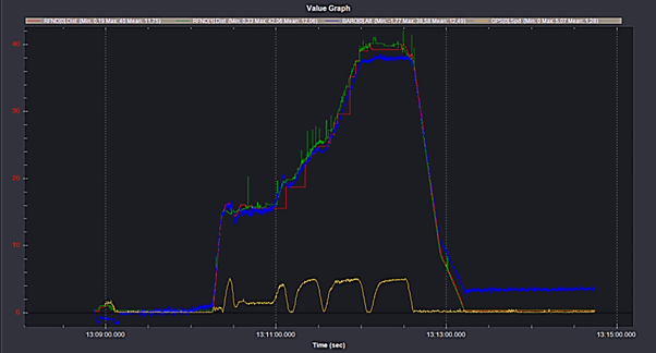
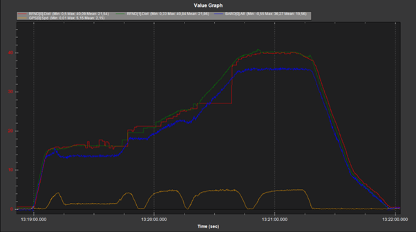
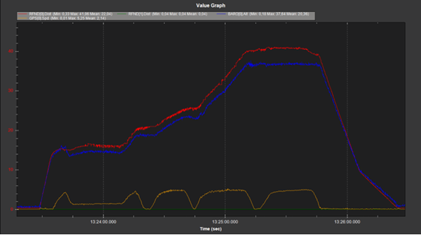
Despite the demanding conditions, the LiDAR data remained significantly more stable than the onboard barometric reference, which drifted by some 2m.
The testing also reinforced the importance of configuration and signal processing when operating over water. Update rates, filtering behavior, and return handling all influence how effectively the sensor maintains stable measurements in these conditions.
Figures 1-3 below illustrate the relationship between LiDAR altitude data, barometric altitude, and GPS speed throughout the test flights.
Why LightWare LRFs Handle These Conditions Better
Measuring over water is about extracting a reliable distance from a signal that is often weak, scattered, or competing with noise.
LightWare microLiDAR® LRFs are specifically designed to handle these conditions. Here’s how:
Pulse Rate
By operating at a very high pulse rate, the sensor is not relying on a single return, but continuously sampling the environment. Measurements are not treated in isolation, but used to build up a stable distance estimate over numerous returns.
This increases the likelihood of capturing valid returns, even when conditions are inconsistent from moment to moment. Our sensors also smooth out short-term inconsistencies caused by wave motion, partial reflections, or transient signal loss.
Advanced Algorithms
LightWare microLiDAR® sensors use advanced algorithms to identify and prioritize valid returns, even when multiple reflections or competing signals are present. This becomes particularly important in instances when the water is clear.
Noise Filtering
LightWare sensors provide robust noise detection and filtering, allowing them to distinguish true returns from unwanted signals and maintain measurement integrity in bright conditions.
Although these are outstanding capabilities, operators should note that performance over water does come with some trade-offs.
Effective range is typically reduced compared to solid targets due to the complexity of the sensing environment. For example, a sensor capable of 200m under ideal conditions may deliver reliable readings over water at significantly shorter distances, depending on conditions.
This is not a limitation of a specific sensor, but a characteristic of the application.
The focus in these scenarios is not maximum range, but maintaining stable and usable measurements within the required operating envelope.
Configuration Matters
Setup and configuration are crucial for achieving stable performance over water.
Key factors include update rate, filtering and signal processing, and mounting angle.
Maintaining a relatively low update rate allows the internal filters sufficient time to compensate for intermittent or inconsistent return signals. In these conditions, using the filtered median output is also beneficial, with the filter size adjusted according to the specific application requirements.
A number of test flights may be necessary to fine-tune these settings, though we recommend starting with a filter size of 10 readings.
While this was not the primary focus of the testing, it has proven to be a reliable and effective method for determining an optimal filter size.
For operators working in these environments, we recommend engaging with the LightWare support team or referring to our support resources to determine the most suitable configuration for a specific deployment.
The Bottom Line
Our tests demonstrated that reliable distance measurement over water is achievable with the right sensor architecture, signal processing, and configuration.
While water remains one of the more demanding environments for UAV altitude sensing, it’s also where differences between LRFs become most apparent. In real-world conditions, many struggle with signal loss, instability, inconsistent returns, or drift over time.
LightWare LiDAR sensors are not among them.
Our sensors are designed to maintain stable, usable measurements in challenging environments, including over water. They provide a reliable absolute reference to the surface below, even under harsh sunlight and optically-challenging conditions.
Contact LightWare today to find the right solution for reliable distance measurement over water and other demanding environments.

Blog written by
Mohit Morar
Mohit Morar is a Technical Support Manager specialising in helping customers successfully integrate LiDAR sensor solutions across both hardware and software environments. With a background in Mechatronics Engineering, a Master’s degree in Electrical Engineering, and an MSc in Control Engineering, Mohit brings a strong multidisciplinary technical foundation to his role.
Prior to joining the LiDAR industry, Mohit worked at Thyssenkrupp in the EC&I department, supporting mining machinery upgrades and maintenance. This experience provided him with valuable exposure to complex industrial systems and practical engineering challenges.
Known for his level-headed, respectful, and helpful approach, Mohit is passionate about understanding technical challenges and working collaboratively with customers to find practical, effective solutions
Never miss a story
Stay updated about Lightware news as it happens.